Monday, May 25, 2020

John Kirk’s Survey’s

As noted in the previous blog post, John Kirk was an early settler to Montgomery County, North Carolina. Early State Census lists for Montgomery County taken between 1784 and 1787, notes John as living in District number 4 and listed as 133 out of 136 men who lived among him in the same District.

As seen by the number of land grants, John, upon settling in Montgomery County, had by 1799, earned the title of Esq by his name.


The earliest land grant I could find for John Kirk with reasonable assurance that it was the John Kirk I am writing about, is dated 16 Apr 1794. The survey was completed in 1797 and the land registered in 1798. Per the early state Census records, John Kirk was already living in Montgomery County prior to 1794, in fact, it looks like he had been a citizen in the county for nearly 10 years.


His first land grant was for 100 acres in Montgomery County on the South West side of the Yadkin River adjoining the land of West Harris Senior and James Rogers. Chain carriers for this survey were Buckner Kimbel and Peter Kimbel.


Again, on 16 Apr 1794, John entered 100 acres of land in Montgomery County on the South West side of the Yadkin River on both sides of Lick Creek adjoining his own lands. Chain carriers were Thomas Cook and Stephen Tredwell.

It is interesting to note that John Crump, Entry Taker, noted that Moses Freeman lived on his land.


In 1795, John Kirk entered 300 acres of land in Montgomery County on the South West side of the Yadkin River adjoining the lands of William Merriman and Nicholas Merriman. Chain carriers William Merriman and Thomas Cook.

John Crump, Entry Taker, notes that the land joins that of Vandike and Joshua Carter, my own land that joins West Harris including Thomas Cook’s improvement.


In 1798, John enters 150 acres of land on the South West side of the Yadkin River joining the lands of Stephen Tredwell and his own line. Chain carriers were Parham Kirk and Nicholas Merriman. Entry Taker notes that the land joins Richard Parker, his own land on Lick Creek.


In 1799, John enters another 150 acres of land in Montgomery County on the South West side of the Yadkin River on the waters of Lick Creek joining the lands of Parker, Burton and Merriman. Chain carriers were Nicholas Merriman and Thomas Polk.

John Crump, Entry Taker, writes out the survey as the waters of Rials Creek (we now know that Lick Creek and Rials Creek are probably the same creek) joining the lands of Stephen Tredwell and including Roger’s improvement.


By 1799, John Kirk has become a pillar of society and an Esq is added to his name. He enters 200 acres of land in Montgomery County on the waters of Curtail Creek adjoining the lands of the Entry Taker, John Neal. The survey completed by 1801 by Thomas Cotton and Chain Carriers are James Mory and William Crowell.

The Heirs of John Kirk, Dec’d

To my knowledge, I am not a direct descendant of the Kirk family. I became interested in learning about the Kirk family because they once lived in the same area as my Marks and Fesperman families. Therefore, knowing about the Kirk’s might bring some knowledge about my own direct ancestors.

According to Friends of Morrow Mountain website, early settlers to what was then Montgomery and now Stanly County, “A 1733 map that included the area that became Stanly County showed no European settlements but by May of 1773 Henry Munger settled along the Yadkin at a place opposite the mouth of the Uwharrie River and a little down from the turbulent Narrows, where he established a ferry to cross the Yadkin/Pee Dee. When Montgomery County was formed in 1779 the NC General Assembly specified that the first court should be held in the home of Henry Munger and a year later the first Montgomery County Court House was completed. From 1788 to 1794 many of Munger’s holdings, including his early ferry, were purchased by James Tindal. (There were several ferries in the area.) The Montgomery County Court House was moved across the river to the new community of Henderson in 1796 and to several other locations near the Pee Dee River. In 1816 the courthouse was moved to Lawrenceville and eventually to Troy.

Current day mouth of Uwharrie River as seen from Stanly County
Others settled nearby and this growing community, that became known as Tindalsville, attracted other adventurers like Munger and Tindal who thought that significant money could be made by transporting goods by commercial barges down the Yadkin/Pee Dee to Cheraw S.C. and onto Georgetown at the coast. They thought Tindalsville would become an important riverway transit hub. These early efforts to move goods downriver did not prove successful nor did later far more ambitious plans to build canals, discussed at length in the NC General Assembly, prove successful. The failure of the commercial transport of goods down the Yadkin/Pee Dee River was perhaps the major reason that Tindalsville gradually lost its drive and energy as a community. Tindalsville was granted a US Post Office on July 1, 1799 and it was permanently closed in 1824.

The Salisbury/Fayetteville Market Road and the ferry crossing at Tindalsville proved to be the primary way of transporting the growing number of goods. John Kirk purchased and operated the now vital ferry and the Kirk Inn was built for ferry travelers. Kirk’s Ferry later became Lowder’s Ferry. Several well-established homesteads were spread around what is now park land. Dr. Francis Kron (1798-1883) and his daughters Adalaide (1828-1910) and Elizabeth (1831-1896) were the most famous of the homesteaders. Kron was the key physician for the area and was very involved with the establishment of Stanly County in 1841. The Kron homestead has been re-created at the park. Kron purchased his 234-acre homesite in 1834 from the Rev. McGregor, “a Scotsman, who preached for the Baptists.” Other noted sites include: Dicksville School, Stony Hill Methodist Church, and homesites of Rush, Lilly, Fesperman, Lowder, Russell, Kirk, Blaylock and Stoker.”

At Family Search is located a plentiful array of North Carolina estate files; some ranging to just one page and others to hundreds of pages. The North Carolina estate files are arranged in a user-friendly way and I found John Kirk’s file among others with a surname that begins with the letter K. In parenthesis next to the names is added the year of probate, which is a nice thing to have. Clicking on the name, the file opens in a viewer where it can be enlarged to make reading easier, downloaded and saved to a personal drive or printed to include in a family book.


Upon opening the file, the first thing I noticed was the tab on the folder. The contents of this file were donated in 1970 by Mrs. A.B. Marshall of Houston, Texas. I am not sure who she is but am grateful to her that she would share such valuable information from her own private collection for others to use. Without these types of donations, these records are lost to history forever. So, thank you, Mrs. A.B. Marshall.


The first two pages in the collection show a map of the survey of the land division of John Kirk to his legal heirs. It is difficult to read as shown so I downloaded the images and put the map together on one page and listed the heirs to make it a bit more user friendly.


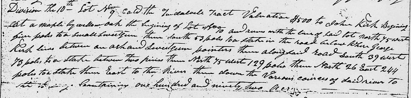
There is a total of eleven pages in this file and, due to multiple copies of pages, it a bit of a challenge to put it all together. I found it easier to work with by cropping out the ‘Divisions’ and transcribing them separately, as seen below. At the bottom of the second page begins the description of the allocation of the land.


The above plats represent the lands of John Kirk Dec’d and agreeable to an order of court of October session 1819 I did proceed to lay off and survey for the commissioners appointed by sd order to divide the sd lands between the heirs of sd Kirk Dec'd and have agreeable to their directions divided the same in the manner and form following with the valuation and number of each division their various courses and distances & below stated.


Division the first lot No 5 valuation $561 to Parham Kirk bounded as follows Beginning at a pine standing about fifteen rod south of the county line and runs thence south 256 poles crossing Ryals Creek to a sweet gum the corner of lot No 7 thence with that line and the line of lot No 6 North 50 East 238 poles to a pine by two pine pointers thence north 30 poles to two pines on Millers line thence as his line West 34 poles two ??? thence North 70 poles to a corner thence West 150 poles to the beginning. Containing one hundred and eighty-seven acres as will appear in the above plat.


Division the 2nd lot No 7 valuation $561 to Lewis Kirk lying on both sides of Ryals Creek beginning at a stake standing in said creek between a hickory maple and oak pointers Caleb Goomious corner and runs with his line west forty two poles to a pine thence as his other line south thirty five east two hundred and ten poles to a post oak thence north fifty six east one hundred and fifty five poles to a red oak thence north thirty four west twenty poles to a maple by a willow oak thence north thirty nine west one hundred and eighty two poles to a dogwood by a dogwood pointer on a line of lot No 5 thence with said line south fifty west one hundred and six poles to its corner sweet gum thence south four poles to the beginning. Containing one hundred and eighty-seven acres as stated in the above plats.


Division the 3rd Lot No 6 valuations $561 to Polly Moss. Lying on both sides of Ryals Creek beginning at a pine by two pines the beginning corner of a hundred acre survey and runs with a line of lot No 5 south west one hundred and thirty two poles to a dogwood by a dogwood the corner of lot No 7 thence with a line of said lot south thirty nine east one hundred and eighty two poles to a maple by a willow oak thence east 54 poles to an ash by two ash pointers in a swamp thence north 30 west 114 poles to a stake between a hickory and red oak pointers thence east 121 poles to a pine thence north 127 poles to a hickory by a sweet gum thence west 127 poles to the beginning. Containing one hundred and eighty-seven acres.


Division the 4th Lot No 3 valuation $440 George Kirk. Lying on both sides of Lick Creek beginning at a pine by a hickory and post oak pointers on the south side of said creek and runs forty west ninety poles to a pine by a pine pointer thence 80 45 west one hundred and seventy nine poles to a blackjack by a post oak thence south forty five east 70 poles to a small post oak thence north forty five (?) east sixty eight poles thence south forty five east one hundred and fifteen poles to a post oak thence north 45 east 112 poles to a pine by a red oak thence north 45 west 115 poles to the beginning. Containing one hundred and eighty acres.


Division the 5th Lot No 1 valuation $500 to Daniel Kirk. Lying on the south side of Lick Creek beginning at the same corner of Lot No three a pine by a hickory and post oak pointer and runs with the last line of lot No 3 reverse south forty five east 115 poles to a pine by a red oak thence with another line of said lot south 45 west 112 poles to a post oaks thence south 45 east 108 poles to a Spanish oak thence north 45 east 196 poles to a small hickory thence north 45 west 221 poles to a post oak by a hickory and red oak pointers thence north 45 west 84 poles to the beginning. Containing one hundred and ninety acres.


Division the 6th and Lot No 4 valuation $175 to Nancy Jones beginning at a black oaks the beginning corner of the old hundred and fifty acre survey near the west bank of the Yadkin River and runs south forty five west 175 poles to a small red oak thence south 45 east 155 poles to a small hickory thence north 45 east ?75 poles to a sassafras by a red oak pointer near the west bank of said river


Division the 7th Lot No 2 valuation $475 to Stephen Kirk lying on Lick Creek and Clover Fork lying in two different tracts first tract on Lick Creek beginning at a post oak and runs thence east eighty poles to a pine thence north 56 poles to a pine by a pine pointer thence north 54 west 114 poles to a post oak thence south 45 west 20 poles to a post oak thence north 45 west 70 poles to a hickory by a post oak thence south 10 west 76 poles to a red oak on Merrimon’s line thence with is line south 63 west 78 poles to a post oak thence north on other of said Merrimon’s line south 16 west 169 poles to a small red oak thence south sixty poles to a stake between two red oaks and a blackjack pointer thence east sixty four poles to a hickory thence north to and with George Hearn's line to the beginning containing one hundred and fifty one acres. Second tract lying on the head of the clover fork beginning at a sassafras by two red oak pointers William Crowel's corner and runs with his line south fifty four west 118 poles to a post oak Moors old corner thence south 26 east 52 poles to a Spanish oak maple and red oak pointers thence north 65 east 112 poles to a stake by a white oak red oak and sassafras pointers thence south 25 east 76 poles to Watkins line thence as his line north 52 poles thence north 36 west to the beginning containing 56 acres the two tracts contain in the whole two hundred and six acres.


Division the 8th and Lots No 8 valuation $250 to Rebekah Jones lying in two tracts adjoining one tract of 150 acres called the Walkr (Walker?) field tract beginning at a post oak by a read oak pointer courses not known but may be had by having reference to the Petition (?) granted to sd John Kirk Dec’d also fifty acres adjoining the same survey William Harris and Richard Parker's lines and Stephen Kirk's also.


Division the 9th Lot No 10 valuation $2000 to Alexander Kirk bounded as follows. Beginning at a maple by a willow oak at the mouth of a branch just above the ferry landing and runs north seventy five west five poles to a small sweet gum thence south 53 poles to a stake in the road below where George Kirk now lives between an ash and sweet gum pointers thence with the various courses of said road south 39 west 73 poles to a stake between three small pines thence north 75 west 14 poles to a small white oak thence south 20 west 44 poles to a post oak thence south forty six 25 poles to a stake by a red oak and post oak sapling pointers marked with a knife thence south fifty east 123 poles to a stake between a white oak and Spanish oak pointers thence east 124 poles to a hickory on the west back of Pee Dee River thence up the various courses of said river to the beginning containing one hundred and fifty two acres with the addition of three quarters of an acre on the east side of said river at the mouth of Uwharrie for the ferry landing.


Division the 10th Lot No 9 called the Tindalvile Tract valuation $500 to John Kirk. Beginning at a maple by willow oak the beginning of Lot No 10 and runs with the line of said lot north 75 west five poles to a small sweet gum thence south 53 poles to a stake in the road below where George Kirk lives between an ash and sweet gum pointers thence along said road south 39 west 73 poles to a stake between two pines thence North 75 west 129 pole thence north 26 east 244 poles to a stake thence east to the River thence down the various courses of said River to the beginning containing one hundred and ninety two acres.


Division the 11th and Lot No 11 valuation $1000 to James Kirk called the Berry tract lying on the east side of the Pee Dee River beginning at a hickory standing at the mouth of Island Creek and runs north 25 east 220 poles to a post oak thence west 28 poles to the road thence with the various courses of sd road to the Town Line of Henderson thence with the town line So 20 East 6 poles to a stake thence south 70 west 68 poles to the River containing one hundred and thirteen and ¾ acres by an addition of 2-3/4 acres being added which by his on the east branch of the river sold to John Kirk Dec’d by the commissioners appointed for that and other purposes containing in the whole on thousand nine hundred and seventy five ½ acres by estimation that the valuation of the whole amount is seven thousand and twenty three dollars.


Made out for the commissioners this the first day of January 1820. Britain Chappell

Sunday, May 24, 2020

James Marks

The Marks research continues.

I recently had the privilege to visit Stanly County and toured the property that belonged to James Marks, my fifth great uncle, in the 1820s. James moved his family from Chatham County, North Carolina to then Montgomery (now Stanly) County, North Carolina, sometime between 1820 and 1825. He purchased land in the area of Stony Mountain, around current day Clodfelter Road.

What brought James to Montgomery County is a mystery to his descendants.


James did not live long after his arrival to Montgomery County as his wife, Caty Gunter Marks, is found on the 1830 Montgomery County Census as head of house, with no husband. Prior to 1830, James Marks is faithfully found on the Chatham County Census for years 1800, 1810 and 1820.


I do not believe that James was born in Chatham County, nor were any of his siblings. Chatham was formed in 1771 from Orange County, which formed in 1752 from parts of Bladen, Granville, and Johnston Counties. Prior to 1800, there are no Marks in Chatham or Orange Counties, North Carolina.

I believe that ‘Daddy’ Marks is the William Marks found on the 1800 Census for Chatham County listed as over the age of 45, making him born prior to 1755 and the perfect age to be the father of James and his siblings. I am now researching on where William Marks may have come from.

Family research has found several children who may be the siblings of James. We know for sure that James had a brother named John, who is my direct line, and who married Mary Gunter, the sister of James’s wife, Caty Gunter Marks. Both Caty and Mary are listed in the will of their father, Isham Gunter, Chatham County. John Marks is found many times in Montgomery County, North Carolina. He is often found in Daniel Freeman’s General Store ledger from the 1830s. He also signed the petition to divide Montgomery and form Stanly in 1838. John is never found on a Census for Montgomery County, rather, he is faithfully in Chatham County and found on that Census for years 1800-1840.

Other siblings to James and John include William Marks Jr who is found early in Bladen County and married Margaret Salter, the daughter of William and Sarah Lloyd Salter. Much research has been done on this family line. Susan Marks, another possible sibling, married Abner Gunter of Chatham County and lived her entire life there. Ewell Marks, who is found in Bladen County performing Chain Carrier duties for his brother, William Jr, and the McKay family.

Lastly, is George Marks, who is found on no Census, but one mention is found of him in one obscure record eluding to the fact that George married the daughter of Richard Kennon of Chatham County who died in 1793 leaving a widow, Celia Ragland Kennon and children Elizabeth, Mary, William, Richard, John, Charles, Celia and Thomas. Richard’s probate records show that at the time of his death, his older daughters, Elizabeth and Mary, were married and mentions their husbands in the petition. The only daughter who was not married was Celia. I am working to track her down, but she seems to have disappeared.


Except for Ewell Marks, and George Marks of whom I know nothing about, all these Marks siblings look to have died prior to the 1850 Census so there are no clues provided as to what state they might have been born as would be listed on Census records beginning in 1850. My cousin has written a fascinating Blog about Ewell Marks finding a possible birthplace for him as Fauquier County, Virginia as noted in his 1812 military record.

From the Fauquier Historical Society webpage, I found that the “area now known as Fauquier County was listed as part of the Northern Neck of the Colony of Virginia by Captain John Smith in 1608. In 1759 Fauquier County was formed from a portion of Prince William County. The name Fauquier was chosen in honor of Francis Fauquier, the Governor of Virginia from 1758-1768. The county encompasses 666 square miles of land in the Piedmont region of Virginia. Today it is best known for its picturesque rolling hills, horse farms, wineries, and history.”

So, it is very possible that 'Daddy' William Marks was born in Prince William County, Virginia prior to 1755 and found himself living in Fauquier County as a young boy when the new county was formed. By the time Ewell was born in the late 1770s to early 1780s, Fauquier County, Virginia was a hotbed of Militiamen, Soldiers and back country farmers who were entrenched in fighting the Revolutionary War.

Fold3 shows two cards for a William Marks who fought in the Revolutionary War. One card states that William Marks died 26 Dec 1778 and the other card states to see also 10 VA Regt. I am thinking that this is the same man.


Revolutionary War pension files for Virginia show Edward Marks who was born in the county of Surry in 1757. He filed for his pension on 28 Apr 1834 in Surry County where he resided when he enlisted and continued to reside since. Not much else is known of him from the file.

Captain Isaiah Marks, whose Revolutionary War pension is filed for by Thomas Marks who states that he is Isaiah’s only brother and heir at law. Isaiah Marks looks to have died in 1785, single, with no issue. However, all his brothers and sisters, nieces and nephews are listed in the pension file. This Marks line is connected to a Rev. John Marks and Uriah Ledyard. An internet search on these names will yield much data.

Some descendants of this line migrated to Kentucky and Tennessee.

The last Marks found in Virginia is John Marks who married Lucy Meriwether Lewis in Virginia, the widow of William Lewis. William and Lucy were the parents of Meriwether Lewis who commanded Jefferson’s great expedition to explore the Missouri and Columbian Rivers from 1804 to 1806. John Marks was connected to President Thomas Jefferson as his brother had married Anna, the sister of the President. More information can be found on this Marks line at www.monticello.org.

This Marks line migrated to Georgia and spread to Alabama and possibly Arkansas, Kentucky, Tennessee and Ohio.


I also explored the William Marks who lived in Warren County, North Carolina. He married Tempy Wright, the daughter of William Wright and Rhocksilary Howell. From Abstracts of Warren Co., N. C. Will Book 3 April 1779 - May 1783, from Original by Mary Hinton Kerr, I found that William Wright’s 1781 will mentions his daughter Tempy Marks. Of interest, Tempy has a brother named Uell (Ewell). I have not found the names of the children of William Marks and Tempy Wright.

I found that William Marks made a purchase at the estate sale of William Wright in Nov 1781.

100. (A) Will of WILLIAM WRIGHT. 21 Feb.1781; Aug. Ct.1781. Names: "Children now living": TEMPEY MARKS, SIMON, ELIZABETH, SUSANNAH, JOHN, UEL(L), & NANCY WRIGHT; Gr-son SIMON LONG. Land on Deep (Creek) bought from Capt. JOHN HAWKINS & land on Wolf Branch bought from WILLIAM GUTRY. Extrs: Capt. PHILLIP BURFORD & SAMUEL PASCHAEL. Wit: THOMAS NEWMAN(Jurat), DANIEL ELLINGTON (Jurat) & JAMES ELLINGTON (Jurat).

112. 20 Sept.1781; Nov.Ct.1781. Acct. Sale Est. WILLIAM WRIGHT, dec'd., by JOHN HAWKINS, Shf. Purchasers: Maj. LEONARD HENLY BULLOCK; Capt. PETER TWITTY; Capt. JOHN HAWKINS; MAJ.PHIL HAWKINS; Mr. JOHN WRIGHT; Mr. THOMAS EVANS FOOTE; Mr. WILLIAM MARKS; Mr. WYATT HAWKINS; Mr. JOHN LONG; Mr. FRANCIS MALLORY; Mr. STERLING CLACK; Miss ANNE WRIGHT; Mr. EUEL WRIGHT; Mr. LEW TUCKER Mr. GEORGE TWITTY; Mr. SIMON WRIGHT; JOHN ROOKER

There is a possibility that William Marks who married Tempy Wright is the son of Fennill Marks who died in Bute County, North Carolina in 1777. Fennill’s widow is listed as Amey Marks. However, there are no other Marks listed in the probate records. Bute County is a former county located in the state of North Carolina. It was formed on June 10, 1764 from the eastern part of Granville County by the Province of North Carolina General Assembly. In 1779 Bute County was divided into Franklin County and Warren County and ceased to exist (Wikipedia).


DNA testing has yielded the original results with my Marks line that I was looking for. Finding my fourth great grandparents was the reason I DNA tested. Now that I have succeeded in finding my fourth greats, I am looking to move on to my 5th greats. DNA testing has not been successful in this quest. A DNA cousin volunteered to Y-DNA test for our Marks line, but he has no matches are Y-37 or Y-67. None! In more than a year. Not one hit. Autosomal (at) DNA testing has not yielded much fruit either. I can connect almost all atDNA matches back to Chatham County, North Carolina but then the collective research begins to fall apart.

No one seems to know where the Marks in Chatham County came from. And records are not showing themselves yet. I think a good place to start is finding out what the connection to the McKay family from Bladen County, North Carolina is. I’m working on that. Bladen County does not have a lot of online records, so, I am planning a research trip there and to the North Carolina Archives as soon as time and current conditions will allow.

Another good place to begin is with the Clark family of Chatham County, North Carolina. John Marks, my fourth great grandfather, in 1810, had a dispute with an Alexander Clark and 300 acres of land had been levied to settle what may have been a debt owed. I have been attempting to find this court case, but to no avail. It may be at the state archives, and it is on my list of items to check for.


Further research has found that most William Marks and Margaret Salter descendants have a legend passed down about the progenitor of their family, William Marks, an English Revolutionary war soldier. He was wounded in battle and left behind. He started his life in America in Chatham County, North Carolina. Perhaps there is some truth to this and a lone DNA tester from England will someday Y-DNA test and answer the question of the parentage of ‘Daddy’ William Marks.

Until then, there are a lot of other leads to follow up on regarding my Marks research.

Saturday, April 11, 2020

200 acres on Cedar Creek

Anyone who has followed my Blog knows I have a great interest in anything pertaining to the Morgan family who lived in what is now the Uwharrie and Eldorado areas of Montgomery County, North Carolina. Mainly because they are, and have been for many years, a genealogical mystery. This Morgan line has not been researched enough to fully understand where they came from and how all the allied family members connect to each other.

While browsing through North Carolina Land Survey files at Ancestry, I found a document that has given me pause about Hardy Morgan and I wonder again whose son he is. Before finding this land survey, I had uncovered several documents that might indicate Hardy was the son of Charles Morgan who migrated from Chatham County to Montgomery County about 1805. I still hold that belief because, based on what documents I have found to date, that seems the most logical option. However, I am not opposed to changing my mind if other documentation reveals itself.

In a land survey for Montgomery County is found one of the earliest mentions outside the 1810 Census on Hardy Morgan; he and Zachariah Morgan are performing the duties of Chain Carriers in 1811 for a tract of land for William Blaylock.

The 6th day of October 1811, Will Stone, the Entry Taker for the county of Montgomery, wrote, “To the surveyor of said county greeting you are hereby required to lay off and survey according to law a tract or parcel of land containing two hundred acres for William Blaylock on Cedar Creek joining his own line and Andrew Dennis line…”


On 19 September 1813, David Cochran, then county surveyor, “surveyed and laid down a plat representing 200 acres of land in Montgomery County on the south east side of Uhara (Uwharrie) River on Cedar Creek beginning at a red oak Andrew Dennis corner and ran to his own corner…”

Hardy Morgan and Zachariah Morgan Chain Carriers.


This is not the only time Hardy is found with Zachariah Morgan. In the Revolutionary War pension file of John Stewart, dated 1833, is found the deposition of Zachariah Morgan that was taken by Hardy Morgan. I know Hardy and Zachariah are related, I just do not know how.

I do know that Hardy is not Zachariah’s son because in the Revolutionary War file of John Stewart, Zachariah, in his deposition, states he was about 12 years of age at the close of the American Revolution and lived in Chatham County, North Carolina, which puts his birth year about 1771.

In Hardy Morgan’s War of 1812 file, his widow, Nancy Hearn Morgan, states that Hardy was born 1 Apr 1785 in Chatham County, North Carolina. Zachariah was 14 years old when Hardy was born so he cannot be Hardy’s father. Zachariah is either Hardy’s Uncle or his cousin.

Zachariah Morgan may be the son of Charles Morgan who died in Chatham County in 1787 and left a will naming his children as Joseph Morgan, Charles Morgan Jr, Edward (or Edmond) Morgan, John Morgan, Zachariah Morgan, William Morgan, Hannah West, Rachel Stewart.

Based on age, it is likely that Zachariah was born late in life to Charles Morgan. I do not think Zachariah is the grandson of Charles as the ages of Charles's children just cannot fit Zachariah in a timeline to be one of their children. There is only one grandchild mentioned in the will of Charles Morgan, his granddaughter, Jeane Stewart, obviously the daughter of John and Rachel Morgan Stewart. I know that Charles Morgan had other grandchildren at the time of his death though. His son Joseph had at least two young children born before 1787 and Charles Jr had at least two children born before his death in 1787, Hardy Morgan possibly being one of those children born in 1785, two years before Charles Sr died.

I am not sure why only one grandchild is mentioned in Charles Morgan’s will, but it is something that prevents me from declaring with certainty that I have the correct Morgan family.


Mentioned also in the William Blaylock survey is Andrew Dennis, who is my 4th great grandfather. I descend through his son, James Dennis and his wife Mary Morgan, whom MAY be the daughter of Zachariah Morgan. Some research suggests that Mary is the daughter of Joseph and Susannah Smart Morgan, but that cannot be as Susannah is too young to be Mary’s mother (she was only 6 when Mary was born) and there is no female, Mary’s age, ever found on the Census records in the household with Joseph and/or Susannah. I think it more realistic that James Dennis married the girl next door. If Mary is the daughter of Zachariah, then that makes Zachariah my 4th great grandfather.

Like the Morgan family, I have found discrepancies with the research previously done on Andrew Dennis. Researchers cannot agree on timeline dates for his life and when dates do not add up in an ancestor’s life that usually means there is a missing generation, or we have the wrong information.

Of interest, there was a James Dennis in Anson County, North Carolina who lived on Twelve Mile Creek in the year 1762. Land Grants show his neighbor as one William Givians. There is also a George Dennis and a Nathaniel Dennis shown in early Anson County deeds. Of interest, most researchers seem to agree that Andrew Dennis’s father was named Nathaniel Dennis, however, your guess is as good as mine as to how they came up with that name.


In 1778 or 79, Andrew Dennis signed a Petition to Governor, Council and Assembly from the inhabitants of the upper end of Anson (now Montgomery) county for a division to form Montgomery County, showing that Andrew Dennis was in the Anson County area prior to 1779 and that he was older than 21 years, the legal age to have signed a petition, meaning he was born prior to 1757. The 1800 Census concurs with this record showing Andrew Dennis was older than 45 years. The 1830 Census shows him to be between 90 and 99 years of age, making him born about 1735.

Montgomery county was formed by an act of the North Carolina General Assembly of 1778 in January 1779 from Anson County.


There are four land grants in the name of Andrew Dennis. Two of them are dated 11 Oct 1783. Grant number 121 is for 150 acres of land in Montgomery County on the North East side of the Yadkin River joining John Edwards, who had been granted land, 128 acres, on the North side of the Yadkin River joining his own corner and Humphrey Ballard’s, dated 11 Oct 1783.

More on John Edwards in another Blog. I am researching the Edwards family because I think they have ties back to Charles Morgan who died in 1787 in Chatham County. I also believe that a Y-DNA match from Tennessee descends from this Morgan / Edwards family.

Humphrey Ballard was granted 193 acres of land on the North East side of the Yadkin River beginning on the side of Gallon Creek and joining John Edwards and Mark Bennett, dated 11 Oct 1783. Mark Bennett had two land grants for Cedar Creek, both dated 11 Oct 1783.

It took me some time to find Gallon Creek as there is no mention of it on any map or old newspaper I could find. I had never heard of it before. I finally discovered an 1889 court case that states Gallon Creek is the same as Island Creek.

Bonaparte v. Carter Supreme Court of North Carolina Feb 1, 189011 S.E. 262 (N.C. 1890) was an action to recover land, tried at Fall Term, 1889, of MONTGOMERY Superior Court, before Merrimon, J

The defendants, in attempting to locate this grant, offered parol testimony for the purpose of showing that the beginning corner of the said Ballard grant started at a point 300 yards distant from Island Creek (which it is agreed by counsel is the same as Gallon Creek) https://casetext.com/case/bonaparte-v-carter or https://www.familysearch.org/ark:/61903/3:1:33SQ-GGTW-P76?i=406&cc=1878751 for the entire case file which tells of how Nancy Bell once owned this land.


Grant number 207 for Andrew Dennis is also for 150 acres of land in Montgomery County on the East side of the Uhary (Uwharrie) River on Cedar Creek near the mouth and includes William Ballard’s improvements. No doubt, William Ballard is a relative of Humphrey Ballard.


In 1795 Andrew Dennis has another Grant for 50 acres on Cedar Creek joining Benjamin Bell, being the father-in-law of Nancy Bell who once owned the Ballard land, and John Walker.


In 1803, Andrew Dennis has a Grant for 50 acres of land on Cedar Creek joining the land of Thompson Clement, John Stewart, John Thompson, and Andrew Dennis. I think this Grant probably belongs to the son of Andrew Dennis but would not be surprised if it indeed belongs to Andrew Dennis Sr.


What is not in doubt is the location where Andrew Dennis lived. All researchers agree that Andrew Dennis lived on current day River Road in Montgomery County on Cedar Creek. The house of his descendants still stands. Some suggest that Andrew Dennis lived in this house, or at least on the foundation where the current house stands.


William Blaylock, the man whom the survey was for, is probably best known to researchers as the father of David Blaylock who married Martha Dennis, the daughter of Andrew Dennis and Frances Blaylock who married Jesse Dennis, the son of Andrew Dennis and brother of Martha.

From his War of 1812 pension file found at Fold3, David Blaylock, on the 11th day of Feb 1851, appeared before a Justice of the Peace in Stanly County, created from Montgomery County in 1841, and declared that he enlisted in the War of 1812 as a Private at Henderson, Montgomery County, about the 25th day of May 1812 for a term of two years. Two witnesses, Daniel and Martha Freeman, provided a sworn statement that they knew both David and his wife Martha before and at the time of their marriage and that Martha’s maiden name is Dennis. Frances also provides a statement and makes note that she is the sister of David and that she married the brother of Martha. So, again, and not surprising, we have a situation where neighbors marry.

Frances shows up in the 1850 Census living next door to James and Mary Morgan Dennis. Her husband Jesse Dennis, dying prior to 1840.


David and Martha show up in Stanly County in 1850 and noted as living with them is Martha Dennis, the wife of Andrew Dennis and mother of Martha. She is 94 years old, making her birth year 1756, and claims she was born in Virginia.


Was Martha the first and only wife of Andrew Dennis? Is it possible that he was born in the 1750s rather than the 1730s as indicated on the 1830 Census? It certainly makes more sense that this would be the case. Is a tick mark in the wrong column on the 1830 Census possible? The 1810 Census seems to agree with Martha’s age on the 1850 Census. Land grants issued, petitions signed, the births of known children, all seem to add up that Andrew Dennis was probably born in the 1750s. Hopefully, more documentation can be uncovered to answer some of these questions.

Saturday, March 21, 2020

Alston Morgan - Update on Morgan Y-DNA Research

I have been working through my cousins Y-DNA matches and MAY have finally broken through a brick wall with one of the matches who descends from Alston Morgan (1803-1860). The Y-DNA match had claimed that the parents of Alston Morgan were William Morgan and Martha Reeder. However, after more than a year of researching William and Martha Reeder Morgan, I now think these two have been confused as the parents of Alston Morgan.


So, I started over with atDNA matches to see if I had missed anything. Going back through more than twenty family trees that listed Alston Morgan (most having his parents listed as William Morgan and Martha Reeder), I found one lone tree connected to an account of a DNA match for my cousin who had an Anderson Morgan born about 1783 in Chatham County, North Carolina in his tree and listed as Anderson's son was Alston Morgan. Listed as Alston Morgan's wife is Ann Edwards whose family is from Chatham County, North Carolina. Attached to this family tree I found the Alston Morgan Story written by a descendant of the Edwards family.

The Alston Morgan Story
This is the story of Alston Morgan. It begins in Chatham County, North Carolina where Alston was born in 1803. His father Anderson Morgan served in the North Carolina Milia during the War of 1812, and was awarded a land grant on Hurricane Creek in Wilson County, Tennessee. Anderson was present on his land grant in the 1820 census. It was noted that he lived among several Edwardses, some of whom were from Chatham County, and were likely old friends. Anderson disappeared from the records afer the 1820 census, and is assumed to have died. He was replaced at that location by Alston Morgan.
Some genealogists may have picked a different father for Alston. But Anderson Morgan was the only Morgan on Hurricane Creek in early Wilson County, and was at the correct location in the censuses to be Alston's father. Anderson Morgan is the only feasible Morgan for the father of Alston Morgan.

Alston has been confused with Moses A Morgan, of Bedford County. It is not known if the two are related.

Alston is a surname, and there were Alstons in Wilson County. A guess is that Anderson Morgan's wife was an Alston.

There is a Wilson County marriage record for Alston Morgan to Ann Edwards, in January 1820. The bondsman for the marriage was Eaton Edwards. Eaton was the son of John Edwards, formerly of Chatham County, NC. This marriage record is the only record in the lifetime of Ann Edwards. She was not even in the census enumerations for anyone. But Ann gave the gift of life to five children, and passed on her DNA. That DNA identified Ann as the daughter of Aaron Edwards, of Chatham County, NC and Hurricane Creek in Wilson County, TN. Ann and Alston were neighbors before they were married. Ann died in or about 1839, as indicated by Alston's remarriage to Julie Ann Abernathy in 1840. Ann and Alston had the following children:
unknown 1820-1828
Charles A Morgan 1828
William Newton Morgan 1829
Jasper R Morgan 1830
Robert W Morgan 1834
Marion Morgan 1836

Aaron Edwards, formerly of Chatham County, NC, sold his property in mid-1803 and moved to newly formed Wilson County, TN. He and his brothers John and Robert are listed as early settlers of Wilson County in Drakes Early History of Wilson County. At the time of his move, Aaron and his wife Elizabeth Hackney had two children. It is believed that Ann was born in Wilson County in about 1804.


Eaton Edwards, the bondsman for Ann's marriage, was her first cousin.
Alston Morgan's second wife, Julia Ann Abernathy, was also a neighbor before her marriage. Born in 1818, her father Charles Abernathy lived two doors over from Alston on Hurricane Creek. Julia Ann finished raising the five children of Ann, and had eight children of her own:
Alexander Morgan 1841
Martha Morgan 1842
Tennessee Morgan 1846
Susan Morgan 1848
James C Morgan 1851
Joseph Morgan 1852
Eliza Morgan 1854
Polly Morgan 1858

Julia Ann was in the 1850, 1860, and 1880 censuses. In the 1880 census at age 61, she was living with her sons Joseph and James, and James' wife and children.
There is no 1890 census, and a search of 1900 censuses failed to find Julia Ann. The 1880 census was the last record in her life.
Many Ancestry family trees have different names for Alston. The only name that ever appears in his historical records is Alston Morgan. The historically correct name is Alston Morgan.
Alston died after the birth of his last child in 1858. He resided on Hurricane Creek all of his adult life. Some of the his descendants still live in the Hurricane Creek area of Wilson County, from Gladeville to present day Norene. He may be buried in one of the cemeteries with his descendants.

Written by an Edwards descendant 11/4/2018


I was very excited to find Alston Morgan’s story as I now had a link back to Chatham County, North Carolina where it is believed my Morgan’s are from. I have been working off and on with this Edwards/Morgan descendant and learned he has done a great deal of DNA and traditional research on the Edwards family and has some good leads on the Morgan family that married into this line.

Ann Edwards's parents are Aaron Edwards and Elizabeth Hackney. Her maternal grandparents are Joseph Hackney and Nancy Stewart. The Edwards and Hackney families can be found in Chatham County land records along with the Morgan, Brewer and Stewart families in the late 1700s. The Brewer family has connections to the Stewart and Morgan families through John Stewart who married Rachel Morgan, the daughter of Charles Morgan II who died in 1787 in Chatham County, North Carolina. The Joseph Morgan listed in the Grantors section below is the son of Charles Morgan II (died in 1787) and the brother of Rachel Morgan who married John Stewart.


From there, things just began falling into place, at least with the Edwards family.

Connected to the Edwards family is the Brewer family. Two daughters of Oliver Brewer, Hannah and Rebecca, from Chatham County, married brothers, John Edwards and William Edwards. I am now researching if John and William's father is the Philip Edwards who is mentioned in the Revolutionary War pension file of John Edwards, who ended up in Jefferson County, Tennessee – the same place William Morgan and wife, Amelia Brewer (from Chatham County, North Carolina) ended up.


You may remember from a previous Blog post that Oliver Brewer is the father of Edward Brewer who migrated to Randolph County, North Carolina. In Edward Brewer's Revolutionary War pension file is found a statement from John Stewart and his two sisters, Barbara and Elizabeth, who married brothers John Russell and William Russell. I can't help but wonder if Nancy Stewart, who married Joseph Hackney, is a relation from a previous generation.

Philip Edwards had a land grant for 100 acres in Montgomery County, North Carolina on the waters of Uhary (Uwharrie) river beginning at ... a corner of his 50-acre tract granted to Andrew Dennis [can this mean that Andrew Dennis sold these 50 acres to Philip Edwards?] ... ran to Hardy Morgan’s line ... to John Stewarts line ... to Bunnel’s corner ... entered 16 Jul 1818 and issued 19 Dec 1820.


Philip Edwards is most likely from Chatham County, North Carolina and migrated to Montgomery County, North Carolina shortly before John Stewart and Charles Morgan came to Montgomery.

I think Andrew Dennis probably sold land to the Morgan's when they came to Montgomery County [based on the verbiage in the land grant above]. A Zachariah Morgan is noted in a Newspaper article as a neighbor of Andrew Dennis in 1813 when some of his land was sold for taxes. Zachariah Morgan provided a statement in John Stewart's Rev War file and I think Zachariah may be John's brother-in-law, sister to John's wife Rachel.

How does all this tie into my cousins Y-DNA matches?

I think it is very possible that Anderson Morgan is indeed the father of Alston Morgan and Anderson is probably the brother of my fourth great grandfather, Joseph Morgan. Anderson most likely married a daughter of one of the Edwards or Alston families, in Chatham County, North Carolina around 1800. When the Edwards’ family moved to Wilson County, Tennessee, Anderson Morgan and his wife went with them, especially since Anderson had a land grant for that place.

About the same time, Charles Morgan II sold his land in Chatham County and moved his family to Montgomery County, North Carolina where his sister Rachel Morgan Stewart was already living. Charles Morgan II is the father of Charles Morgan III who married a woman named Delilah. This couple, Charles and Delilah, are the parents of Willis Morgan who married Bethany Bailey Delamothe, the widow of Henry Delamothe Willis and Bethany migrated to Campbell County, Georgia in the 1840s. The first match listed below descends through Willis and Bethany. I think my fourth great grandfather, Joseph Morgan, may be the uncle of Willis Morgan.

I have one more match to solve. I have sent multiple emails to this match but have heard nothing back. He has Charles Morgan listed as his earliest known ancestor and I have my fingers crossed that this match is also a descendant of Charles Morgan I who died 1787 in Chatham County, North Carolina.