According to Friends of Morrow Mountain website, early settlers to what was then Montgomery and now Stanly County, “A 1733 map that included the area that became Stanly County showed no European settlements but by May of 1773 Henry Munger settled along the Yadkin at a place opposite the mouth of the Uwharrie River and a little down from the turbulent Narrows, where he established a ferry to cross the Yadkin/Pee Dee. When Montgomery County was formed in 1779 the NC General Assembly specified that the first court should be held in the home of Henry Munger and a year later the first Montgomery County Court House was completed. From 1788 to 1794 many of Munger’s holdings, including his early ferry, were purchased by James Tindal. (There were several ferries in the area.) The Montgomery County Court House was moved across the river to the new community of Henderson in 1796 and to several other locations near the Pee Dee River. In 1816 the courthouse was moved to Lawrenceville and eventually to Troy.
 |
| Current day mouth of Uwharrie River as seen from Stanly County |
The Salisbury/Fayetteville Market Road and the ferry crossing at Tindalsville proved to be the primary way of transporting the growing number of goods. John Kirk purchased and operated the now vital ferry and the Kirk Inn was built for ferry travelers. Kirk’s Ferry later became Lowder’s Ferry. Several well-established homesteads were spread around what is now park land. Dr. Francis Kron (1798-1883) and his daughters Adalaide (1828-1910) and Elizabeth (1831-1896) were the most famous of the homesteaders. Kron was the key physician for the area and was very involved with the establishment of Stanly County in 1841. The Kron homestead has been re-created at the park. Kron purchased his 234-acre homesite in 1834 from the Rev. McGregor, “a Scotsman, who preached for the Baptists.” Other noted sites include: Dicksville School, Stony Hill Methodist Church, and homesites of Rush, Lilly, Fesperman, Lowder, Russell, Kirk, Blaylock and Stoker.”
At Family Search is located a plentiful array of North Carolina estate files; some ranging to just one page and others to hundreds of pages. The North Carolina estate files are arranged in a user-friendly way and I found John Kirk’s file among others with a surname that begins with the letter K. In parenthesis next to the names is added the year of probate, which is a nice thing to have. Clicking on the name, the file opens in a viewer where it can be enlarged to make reading easier, downloaded and saved to a personal drive or printed to include in a family book.

Upon opening the file, the first thing I noticed was the tab on the folder. The contents of this file were donated in 1970 by Mrs. A.B. Marshall of Houston, Texas. I am not sure who she is but am grateful to her that she would share such valuable information from her own private collection for others to use. Without these types of donations, these records are lost to history forever. So, thank you, Mrs. A.B. Marshall.

The first two pages in the collection show a map of the survey of the land division of John Kirk to his legal heirs. It is difficult to read as shown so I downloaded the images and put the map together on one page and listed the heirs to make it a bit more user friendly.

There is a total of eleven pages in this file and, due to multiple copies of pages, it a bit of a challenge to put it all together. I found it easier to work with by cropping out the ‘Divisions’ and transcribing them separately, as seen below. At the bottom of the second page begins the description of the allocation of the land.

The above plats represent the lands of John Kirk Dec’d and agreeable to an order of court of October session 1819 I did proceed to lay off and survey for the commissioners appointed by sd order to divide the sd lands between the heirs of sd Kirk Dec'd and have agreeable to their directions divided the same in the manner and form following with the valuation and number of each division their various courses and distances & below stated.

Division the first lot No 5 valuation $561 to Parham Kirk bounded as follows Beginning at a pine standing about fifteen rod south of the county line and runs thence south 256 poles crossing Ryals Creek to a sweet gum the corner of lot No 7 thence with that line and the line of lot No 6 North 50 East 238 poles to a pine by two pine pointers thence north 30 poles to two pines on Millers line thence as his line West 34 poles two ??? thence North 70 poles to a corner thence West 150 poles to the beginning. Containing one hundred and eighty-seven acres as will appear in the above plat.

Division the 2nd lot No 7 valuation $561 to Lewis Kirk lying on both sides of Ryals Creek beginning at a stake standing in said creek between a hickory maple and oak pointers Caleb Goomious corner and runs with his line west forty two poles to a pine thence as his other line south thirty five east two hundred and ten poles to a post oak thence north fifty six east one hundred and fifty five poles to a red oak thence north thirty four west twenty poles to a maple by a willow oak thence north thirty nine west one hundred and eighty two poles to a dogwood by a dogwood pointer on a line of lot No 5 thence with said line south fifty west one hundred and six poles to its corner sweet gum thence south four poles to the beginning. Containing one hundred and eighty-seven acres as stated in the above plats.

Division the 3rd Lot No 6 valuations $561 to Polly Moss. Lying on both sides of Ryals Creek beginning at a pine by two pines the beginning corner of a hundred acre survey and runs with a line of lot No 5 south west one hundred and thirty two poles to a dogwood by a dogwood the corner of lot No 7 thence with a line of said lot south thirty nine east one hundred and eighty two poles to a maple by a willow oak thence east 54 poles to an ash by two ash pointers in a swamp thence north 30 west 114 poles to a stake between a hickory and red oak pointers thence east 121 poles to a pine thence north 127 poles to a hickory by a sweet gum thence west 127 poles to the beginning. Containing one hundred and eighty-seven acres.

Division the 4th Lot No 3 valuation $440 George Kirk. Lying on both sides of Lick Creek beginning at a pine by a hickory and post oak pointers on the south side of said creek and runs forty west ninety poles to a pine by a pine pointer thence 80 45 west one hundred and seventy nine poles to a blackjack by a post oak thence south forty five east 70 poles to a small post oak thence north forty five (?) east sixty eight poles thence south forty five east one hundred and fifteen poles to a post oak thence north 45 east 112 poles to a pine by a red oak thence north 45 west 115 poles to the beginning. Containing one hundred and eighty acres.

Division the 5th Lot No 1 valuation $500 to Daniel Kirk. Lying on the south side of Lick Creek beginning at the same corner of Lot No three a pine by a hickory and post oak pointer and runs with the last line of lot No 3 reverse south forty five east 115 poles to a pine by a red oak thence with another line of said lot south 45 west 112 poles to a post oaks thence south 45 east 108 poles to a Spanish oak thence north 45 east 196 poles to a small hickory thence north 45 west 221 poles to a post oak by a hickory and red oak pointers thence north 45 west 84 poles to the beginning. Containing one hundred and ninety acres.

Division the 6th and Lot No 4 valuation $175 to Nancy Jones beginning at a black oaks the beginning corner of the old hundred and fifty acre survey near the west bank of the Yadkin River and runs south forty five west 175 poles to a small red oak thence south 45 east 155 poles to a small hickory thence north 45 east ?75 poles to a sassafras by a red oak pointer near the west bank of said river

Division the 7th Lot No 2 valuation $475 to Stephen Kirk lying on Lick Creek and Clover Fork lying in two different tracts first tract on Lick Creek beginning at a post oak and runs thence east eighty poles to a pine thence north 56 poles to a pine by a pine pointer thence north 54 west 114 poles to a post oak thence south 45 west 20 poles to a post oak thence north 45 west 70 poles to a hickory by a post oak thence south 10 west 76 poles to a red oak on Merrimon’s line thence with is line south 63 west 78 poles to a post oak thence north on other of said Merrimon’s line south 16 west 169 poles to a small red oak thence south sixty poles to a stake between two red oaks and a blackjack pointer thence east sixty four poles to a hickory thence north to and with George Hearn's line to the beginning containing one hundred and fifty one acres. Second tract lying on the head of the clover fork beginning at a sassafras by two red oak pointers William Crowel's corner and runs with his line south fifty four west 118 poles to a post oak Moors old corner thence south 26 east 52 poles to a Spanish oak maple and red oak pointers thence north 65 east 112 poles to a stake by a white oak red oak and sassafras pointers thence south 25 east 76 poles to Watkins line thence as his line north 52 poles thence north 36 west to the beginning containing 56 acres the two tracts contain in the whole two hundred and six acres.

Division the 8th and Lots No 8 valuation $250 to Rebekah Jones lying in two tracts adjoining one tract of 150 acres called the Walkr (Walker?) field tract beginning at a post oak by a read oak pointer courses not known but may be had by having reference to the Petition (?) granted to sd John Kirk Dec’d also fifty acres adjoining the same survey William Harris and Richard Parker's lines and Stephen Kirk's also.

Division the 9th Lot No 10 valuation $2000 to Alexander Kirk bounded as follows. Beginning at a maple by a willow oak at the mouth of a branch just above the ferry landing and runs north seventy five west five poles to a small sweet gum thence south 53 poles to a stake in the road below where George Kirk now lives between an ash and sweet gum pointers thence with the various courses of said road south 39 west 73 poles to a stake between three small pines thence north 75 west 14 poles to a small white oak thence south 20 west 44 poles to a post oak thence south forty six 25 poles to a stake by a red oak and post oak sapling pointers marked with a knife thence south fifty east 123 poles to a stake between a white oak and Spanish oak pointers thence east 124 poles to a hickory on the west back of Pee Dee River thence up the various courses of said river to the beginning containing one hundred and fifty two acres with the addition of three quarters of an acre on the east side of said river at the mouth of Uwharrie for the ferry landing.

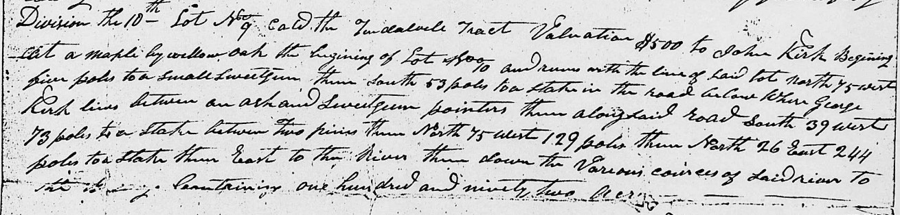
Division the 10th Lot No 9 called the Tindalvile Tract valuation $500 to John Kirk. Beginning at a maple by willow oak the beginning of Lot No 10 and runs with the line of said lot north 75 west five poles to a small sweet gum thence south 53 poles to a stake in the road below where George Kirk lives between an ash and sweet gum pointers thence along said road south 39 west 73 poles to a stake between two pines thence North 75 west 129 pole thence north 26 east 244 poles to a stake thence east to the River thence down the various courses of said River to the beginning containing one hundred and ninety two acres.
Division the 11th and Lot No 11 valuation $1000 to James Kirk called the Berry tract lying on the east side of the Pee Dee River beginning at a hickory standing at the mouth of Island Creek and runs north 25 east 220 poles to a post oak thence west 28 poles to the road thence with the various courses of sd road to the Town Line of Henderson thence with the town line So 20 East 6 poles to a stake thence south 70 west 68 poles to the River containing one hundred and thirteen and ¾ acres by an addition of 2-3/4 acres being added which by his on the east branch of the river sold to John Kirk Dec’d by the commissioners appointed for that and other purposes containing in the whole on thousand nine hundred and seventy five ½ acres by estimation that the valuation of the whole amount is seven thousand and twenty three dollars.

Made out for the commissioners this the first day of January 1820. Britain Chappell

No comments:
Post a Comment