Friday, February 12, 2021

At the mouth of Hall Branch

I am by no stretch of the imagination a surveyor, nor do I claim to understand all the ins and outs of 18th century (or any other century) surveys. I am just now beginning to understand how to identify a general area of where a survey was performed. In time, perhaps I will attain a level of knowledge to expand my understanding of surveys, plats, and deeds, and can transfer that knowledge here to my Blog and more importantly to my genealogical research because it is a must to understand where an ancestor lived and who the neighbors were because neighbors interacted and intermarried with each other. 

A valuable piece of information I came across outlines the linear equivalents that apply when reading surveys and legal descriptions in deeds from the 18th century: 

1 link of a chain = 7.92 inches 

25 links = 1 pole (or 1 rod) = 16.5 feet 

100 links = 1 chain = 66 feet = 4 poles (or 4 rods) 

10 chains = 1 furlong = 660 feet = 40 poles 

80 chains = 1 mile

I recently purchased a program called DeedMapper and hope to utilize that software to assist me in locating property that was owned by my ancestors and incorporate that into my Blog once I learn the most effective way to apply it to my research. I also use My Maps in Google which is free and is very helpful in finding approximate locations of where ancestors lived. 

Turner Harris of Montgomery County (he is highly confused with the Turner Harris of Davidson County) entered a land grant on 11 Oct 1783 for fifty acres of land in Montgomery County on the North East side of Uwharrie River beginning at a red oak near the mouth of the great (Hall) branch on Uwharrie and runs thence South seventy East one hundred Poles to a pine thence South twenty West eighty poles to a stake then North seventy West one hundred poles to a stake thence a direct course to the beginning.


That area today is in Uwharrie, a community located in the Uwharrie National Forest of Montgomery County, North Carolina. Hall Branch runs between Riverbend Road and Morton Road and both of those roads run off River Road. You can take Reservation Road (off Hwy 109) to Cotton Place Road and follow the river until it bends (you can’t see it anymore) to see the area where Turner and Susannah Thomas Harris lived.

An excerpt from a book of Montgomery County Graveyards says of the Turner Harris cemetery: “Found in a Card File in the Randolph Room, Asheboro Library, Asheboro, North Carolina indicates a cemetery in Uwharrie National Forest, Lot 4. There are 3-4 graves, none marked. This may be the same cemetery marked E-4 in Wildlife Rev. and called Cotton Cemetery. Located in Uwharrie Wildlife Reservation on Road #555 (Cotton Place Road) that runs along the river. In a field in E-4, in a grove of trees in Field 7, 4 unmarked stones. A rubbing was made of at least one of the stones at one time and was in the files of the US Forestry Service, Troy, North Carolina. It is believed that the stone marked the grave of Turner Harris (son of West Harris and Mary Turner).”

Turner Harris, through other land grants, did eventually own 380 acres of land on both the east and west sides of Uwharrie River. The map shown below represents the general area of Entry number 459.

You can see all six of Turner’s land grants at www.nclandgrants.com


As noted above, Turner Harris of Montgomery County is often confused with Turner Harris of Davidson County and is often seen in family trees married to Elizabeth Rush. The Turner Harris in Davidson County did marry Elizabeth Rush. The Turner Harris in Montgomery County married Susannah Thomas, daughter of Benjamin and Catherine Thomas. It is possible, but not yet fully proven, that Catherine’s maiden name is Rush.

I recently was in touch with a Thomas descendant and learned of a family bible that she, through some very impressive detective work, tracked down in the town of Eden behind a fireplace mantle that had been removed for repurposing. The bible mentioned her family descending from Benjamin Thomas of Franklin County, North Carolina. The Thomas descendant succeeded in acquiring the bible and she graciously scanned and mailed me copies that are shown below.


Benjamin Thomas died in 1800 in Franklin County. Susannah is mentioned as Susannah Harris in his will. As a note, her sister, Hannah, married Richard Bell and these two sisters lived near one another in Montgomery County. I wrote about Richard Bell last year. Read that post here

Both Turner Harris and Richard Bell were at the 1800 estate sale of Benjamin Thomas in Franklin County, North Carolina. In his will, the 9th item, Benjamin stated that only family members could purchase his slaves and no other person. Any remaining should be divided equally among his children. Turner Harris purchased a slave by the name of Milly and Richard Bell purchased Isaac.


Land Grants were not the only way that Turner Harris, or others, had acquired land. He, along with West Harris, Jesse Harris, John Baker, Thomas Williams, Joseph Bell, Richard Tillman, Cary Pritchard, and John Stewart, in 1786, petitioned for title to lands they had purchased from Henry McCulloh. According to his statement, Turner Harris had, in 1777, tried to pay for the land and receive a title, of which, John Frohock, land agent for Henry McCulloh, had refused him.

Even though McCulloh had spent only about seven years in North Carolina, he was the largest landholder, after Lord Granville, in the history of the colony or the state. According to NC Pedia, McCulloh had profited handsomely by receiving two grants of 60,000 and 72,000 acres, while a third grant of 1.2 million acres to James Huey, Murray Crymble, and their associates actually went to McCulloh since Huey and Crymble were acting as his trustees. The latter grant was awarded on the condition that six thousand protestants be settled on the land and quit rents be paid, but the contract did not have to be complied with for ten years. McCulloh's two earlier grants had also been conditioned on his paying quit rents and installing protestant settlers on the land to produce raw materials needed in England. He fell far short of meeting both obligations and was charged not only with failing to pay the rents but also with conniving with purchasers of his lands to do likewise.

McCulloh agreed to surrender extensive acreage within the tract established as the Granville district to satisfy a claim by Lord Granville. By the time his son, Henry Eustace McCulloh, arrived in 1761 as his agent, the elder McCulloh had disposed of a large percentage of his land other than the tract he was to lose in 1765. The land he retained devolved to his son, Henry Eustace, and all of it was confiscated during the American revolution despite the efforts of his great-nephew, James Iredell, to save it.

It was shortly after the American Revolution that Turner Harris, and others who had purchased lands from McCulloh, petitioned the General Assembly for title to the lands they had purchased from McCulloh.


The McCulloh survey book 1762-1773 by Stewart Dunaway shows a tract of land purchased by Turner Harris in 1763 when Montgomery County was still Anson County.

Plan of one hundred acres of land laid off and subdivided from a larger survey the property of Henry Eustace McCulloh lying on the Uwharrie River beginning at a Spanish oak on the bank of the river the widow McLaine's (now Sargent’s) clearing running thence So 15 Wt at 106 po crossing the river...112 po to a large w.o. on the bank...near the mouth of a branch (probably Hall Branch).

The date on the McCulloh survey for Turner Harris is 1763. It is believed that Turner Harris was born in 1746, thus making him too young to own land in 1763 as he would have only been 17 years old. I believe the date of birth for Turner Harris needs to be pushed back at least 4 years to 1742. This would put Turner at the legal age of 21 to own land.


The North Carolina state Census 1784-1787 pg 3 shows Turner Harris as a citizen of Montgomery County.


The 1790 Census of Montgomery County shows Turner Harris living next door to West Harris Senior and Joshua Hurley. In his household lives three males older than 16, three males younger than 16, five free white females and one slave. 


A 1794 deed that has barely survived time, shows Turner Harris selling land to Arthur Harris. Unfortunately, the deed is badly damaged, so much so that it is impossible to make out the details of where the tract of land is located.


Another deed dated 1794 between Turner Harris and West Harris Jun. shows Turner selling to West Harris a tract of land in Montgomery County on the North East side of the Yadkin River at a Turkey Oak at the mouth of Hall Branch and joining John Baker’s line. Witnessed by Hiram Williams and Arthur Harris Jun.


The 1800 Census shows Turner living between Joseph Hall and Wiley Harris. In his household are one male 10-15, one male 16-25, one male 45 and over, two females between 10-15, two females between 16-25, one female 45 and over and three slaves. One of those slaves probably being Milly who was purchased at the estate sale of his father-in-law Benjamin Thomas.


In 1810, Turner is living between Sam Naylor and Brantley Harris. In his household are one male 16-25, one male 45 and over, two females between 16-25, one female 45 and over and five slaves.

On a recent trip to the North Carolina State Archives, I found a collection titled W. K. Littleton that had several historical papers relating to the Bell family. It is among those papers that I found a receipt signed by Hardy Morgan 31 Jan 1820, “Rec'd of Benjamin Bell Sen. fourteen dollars in part of a note given by said [Benjamin Bell] to Littleton Harris, Hardy Morgan, and Salley G. Harris, Executors to Turner Harris Deceased.”

I have written extensively about Hardy Morgan on this Blog. Littleton Harris is believed to be the son of Etheldred Harris, a brother to Turner. Benjamin Bell is the brother of Richard Bell who married Hannah Thomas, sister to Susannah Thomas Harris.

At this time, Salley G. Harris is a mystery, however, as she is noted as an Executor of Turner Harris, I think she may be his second wife.


In a Randolph County, North Carolina estate file for Phineas Nixon Senior, is found a letter dated 1863, written by Phineas Nixon Junior and makes mention of “Old Turner Harris.”  

“Many years ago, old Turner Harris was father’s agent...after his death Arthur Harris the farmer died during the last war or soon after...”

In 1908, a Notice of Land Sale was advertised in the Newspaper, The Montgomerian (Troy, North Carolina) providing the same description of the land, at the mouth of Hall Branch, that was originally granted to Turner Harris 125 years before, in 1783.


Monday, February 1, 2021

Finds at the Archives

It is amazing what you can find by digging through other people’s stuff, and how, like a set of fallen Dominos, things can just fall into place! There is no such thing as researching just one direct family line. If one hopes to find information on their direct family line, one must research the entire county, especially when records have been destroyed or are missing as that is the only way to piece families together – by record association. 

On a recent trip to the North Carolina State Archives, I found the collection of W. K. Littleton, consisting of 9 folders and the J.R. Coggins collection on microfilm. The collections were donated to the archives by heirs of the Bell and Coggins families. All the folders are full of historical documents on the families of Montgomery County, North Carolina. So, a big Thank You to those family members who decided to share these collections. And a BIGGER THANK YOU to the living heir who gave me permission to make copies of the J. R. Coggins collection – you know who you are! 

Below are a few of the finds that prompted me to order copies from both collections.

Eliza Bell, whom I can only assume is Elizabeth Ledbetter Bell, the wife of Benjamin Bell, made purchases at Hardy Morgan's store between 1826 – 1828. Elizabeth is the daughter of Charles Ledbetter.While researching Charles Ledbetter, I found an early deed, dated 1792, between him and Nathaniel Edwards for land on Island Creek. I had been looking for documentation to prove Nathaniel Edwards was the son of John Edwards, and I found it in this deed that states Nathaniel is the son of John. I am still looking for documentation that might link Elizabeth Edwards to Nathaniel and John Edwards. Elizabeth married first Brantley Harris and second, Arthur Harris, the brother of West Harris. Elizabeth’s sister, Edith, married West Harris. Such a tangled web!

Family Search: Montgomery. Deed Records 1774–1795, Deed Records 1798–1807, Deed Records 1838–1847I’ve wrote a great deal on Hardy Morgan in previous blogs. I believe Hardy may be the brother of my fourth great grandfather, Joseph Morgan. Hardy owned a store in what is now Uwharrie, Montgomery County, North Carolina, called Morgan’s store. The above document was prepared by Hardy and looks to be from his store ledger. Hardy and his family moved to Pontotoc County, Mississippi in the 1840s and after his death in 1854, his wife and several children moved on to Arkansas.

I believe Hardy is the son of Charles Morgan who migrated from Chatham County, North Carolina to Montgomery County, North Carolina about 1805. I do not know who his wife is. She looks to have died before the family left Chatham. Hardy’s wife, Nancy, is another person I am also seeking information on. She declared in her War of 1812 widow’s pension that her maiden name is Hearne. Most researchers have her mixed up with Nancy Hearne, the daughter of Ebenezer Hearne and Dovey Walker, who married Clayton Steed and lived her life in Randolph County, North Carolina. I wrote about that in another Blog.

In another document found at the archives, I learned that Selby Hearne and Isham Coggin turn up with Hardy Morgan in some deeds (see below) and, as most researchers know, whenever two or more names are seen together multiple times, it can lead to some valuable clues that can solve a puzzle. The puzzle I am hoping to solve is who the parents are of Nancy Hearne Morgan.

I have been looking for the following deed since September 2018 when I wrote the Blog E.F. Morgan.

In that Blog I wrote, “On the 2nd day of March 1840, E.F. Morgan, of the county of Montgomery, sold to John Hall, of the county of Randolph, for the sum of $725, and lying on the east bank of Barnes Creek, land that included a Grist Mill and a Sawmill. Two other tracts of land, known to many as the McCulloch tract and Spencer tract, sold to John Hall at this same time.

At the end of the deed the following was added, “the sd E.F. Morgan doth hereby by these presents exempt one acre & a half of the McColloch Tract of land to begin at McColloch’s last corner on Uwharrie River adjoining the lands of sd George Coggin as the same heretofore has been sold to sd Coggin by Hardy Morgan.” The deed witnessed by H. (Hardy) Morgan and A.H. Sanders, proven by oath in open court by A.H. Sanders. That raises the question if E.F. and Hardy Morgan owned this land jointly or if E.F. Morgan had bought the land from Hardy Morgan at some time in the past and they all forgot the one-acre and a half had previously sold to George Coggin until the land sold to John Hall.”

Found among the J.R. Coggin Papers 1813-1868 (File number MIP.7) at the North Carolina State Archives is the deed where Hardy Morgan sold the 1 acre to George Coggins.

This Indenture made the 10th day of October AD 1835 Between Hardy Morgan of the county of Montgomery and state of North Carolina of the one part and George Coggin of the county and state afore sd of the other part witnesseth that for and in consideration of the sum of fifteen dollars to the sd Hardy Morgan in hand paid by the sd George Coggin the receipt whereof is hereby acknowledged and the sd Hardy Morgan doth herby bargain sell and deliver unto the sd George Coggin by these presents a certain tract or parcel of land containing one acre and a half situate lying and being in the county & state afore sd and on the No Et bank of the Uwharrie River adjoining the lands of the sd Coggin being the upper corner of the McColloch tract Beginning on a mulberry stump standing on the No Et bank of sd river … above the mouth of the sd Coggin spring branch and runs … to a sweet gum sapling stands in sd line amongst some dogwood(?) then a So. Wt. course a long a slope (?) & line to a bunch of Burch bushes standing on the bank of sd river amongst a hickory & walnut pointer … to the beginning corner

The same to have and to hold and to be to the proper use of the sd Coggin him and his heirs and assigns forever and him the sd Hardy Morgan doth by these presents for ever warrant and defend the right and title of the sd tract or parcel of land hereby conveyed to the sd Coggin against all lawful claim or claims of any person or persons (?) in witness where of the sd hardy Morgan doth hereunto set his hand and seal the day and year first above written. 

H. Morgan Seal

Signed sealed and delivered in the presents of

Selby Hearn

Isham CogginIn another document I found digging around at the archives, Benjamin Bell signs as security for Jesse Dennis who rented the Dutch John Plantation in 1817 from William Brookshire. Jesse Dennis is the son of Andrew Dennis, my fourth great grandfather. Jesse married Frances Blalock, daughter of William David Blalock Senior. Frances’s brother, William David Blalock Jr., married Jesse’s sister, Martha. I believe the Blalock and Morgan families knew one another from Chatham County and probably came to Montgomery County together in the early 1800s.

Jesse had a land grant for 640 acres of land in Montgomery County in the fork of the Yadkin and Uwharrie Rivers beginning on Brookshire's line (probably the same William Brookshire who owned the Dutch John Plantation) ... and running .... near the new road ... dated 4 Dec 1819. Two of Jesse's horses are named in the deed, Hercules, a bay gelding and Borus, a stud horse. Jesse died between the 1830 and 1840 Census years. I have yet to discover what happened to the 640 acres of land he owned. I am also curious to know who William Brookshire is, so more research to be done on that name.In January 1820, Benjamin Bell Senior paid one dollar, the full amount of his account owing at Hardy Morgan’s store. Hardy Morgan also received of Benjamin Bell Senior fourteen dollars in part of a note given by said Littleton Harris, Hardy Morgan, and Sally G. Harris Executors to Turner Harris Deceased. Turner Harris is another name that I am working on, so this find was of great value to me. Turner Harris of Montgomery County who married Susannah Thomas has been confused with the Turner Harris from Davidson County who married Elizabeth Rush.

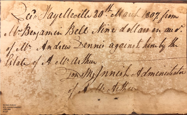
I do not know who Sally G. Harris is mentioned in the below receipt but would almost bet that she is probably his second wife as Susannah Thomas Harris, his first wife, died in 1799. It is obvious by this receipt that Turner Harris is dead by 31 Jan 1820 as he is mentioned as “Dest” (deceased).The below paper has brought about a ton of confusion for me. It looks to read, “Rec’d Fayetteville 20th March 1807 from Mr. Benjamin Bell Nine dollars on aud. of Mr. Andrew Dennis against him by the estate of A. McArthur. Don McInnish Administrator of A. McArthur”

When I first read this paper, I thought A. McArthur may have been related to Nancy McArthur who married Charles Bell, the son of Benjamin Bell, whom the receipt is made out to. However, upon finding Don McInnish had a store in Fayetteville, (he died in 1811 leaving an estate file that can be found on Family Search in Cumberland County) I am now questioning if Benjamin Bell was the administrator of the estate of Andrew Dennis. 

However, Andrew Dennis did not die until after 1830 (he is listed on the 1830 Census for Montgomery as older than 90 years). But why would Benjamin Bell pay a $9 bill for Andrew Dennis against the estate of A. McArthur?

And who is A. McArthur?

More research required here!

I am totally confused over this one and have enlisted the help of some family members to help sort this out.

If you have another interpretation of the below, please post it in the comments section.Now, here is a new name to add to my file: Timothy Lax sold land to George Coggin and he may be the same man who is later found in Hardeman County, Tennessee by the same name. Who is he and what connection does he have to George Coggin? He is found on the 1830 Census living east of the Pee Dee and Yadkin River between Wiley Chappell and Leonard Graves.

Hardy Morgan and his son, Ebenezer Franklin Morgan, signed as witness.The deed is translated as follows:

This indenture the 26th day of January in the year of our Lord one thousand eight hundred and thirty three between Timothy Lax (note: there was a Lax family in Randolph County and I wonder if Timothy may be related?) of the state of North Carolina and county of Montgomery of the one part and George Coggin and the county and state aforesaid of the other part witnesseth that for and in consideration of the sum of seventy five dollars to him the said Timothy Lax in hand paid by the said George Coggin at or before signing and delivering of these presents the receipt whereof is hereby fully acknowledged have bargained sold and delivered and by these presents doth bargain sell and deliver unto the said George Coggin his heirs and assigns forever a certain tract or parcel of land lying and being situate in the county of Montgomery and state of North Carolina and lying on the east side of the Uwharrie River and on the west side of Barnes Creek and being part of a survey of two hundred acres surveyed for Mark Bennett in 1779 as showeth on Bennett’s plat beginning at a pine a line tree of the said George Coggin formally Agrippa A Steed's and a corner tree of Jesse Clifton and runs thence south with the said Coggins ? line and Selby Hearn's line to a stake standing between Selby Hearne’s house and spring thence east ninety three poles to another stake the said Coggins line of his Clemmons tract near the house thence south west the said Coggin line of his Clemmons tract to a branch running southward to Barnes Creek then running the various courses of the said branch to the said Bennett’s old line which is equal to one hundred and seventy nine poles direct from the corner at the Clemmons place thence west one hundred and twenty poles to the beginning containing one hundred acres the same being more or less and all and ? and every the ? to the same belonging on in any wise appertaining to have and to hold the land hereby conveyed and singular ....

Timothy Lacks (his X mark) 

Signed and sealed and delivered in the presence of 

H. Morgan 

E. F. Morgan